This is now the third day with my Garmin 60CSx. I like it, even though the interface is a bit cumbersome. The accuracy is great and the tracking and routing features are fun. In my last post my step-father commented about needing a detailed map to get the turn by turn directions. I hadn’t thought of this before. I didn’t realize that the included maps, labeled “Base Map”, would be so barren of data. I mean primarily only highways and other major roads.
That being said I looked into buying various Garmin produced maps. City Navigator NT is $108, after shipping from Garmin, you can get it cheaper from www.gpscity.com, and has received some bad reviews when compared to previous non-NT versions.
I am hesitant to buy a bad map product for that much money. According to GPScity the new Topo maps from Garmin have trail and road routing as well as topo maps. The TOPO NorthEast map is $138, after shipping from Garmin, again, cheaper at GPScity. I do not know how the routing is on these maps though. For example, can I have it only route using roads and disregard trails? Does it have all the roads that the City Navigator has? I have asked GPScity this just today and am awaiting a response.
While that debate has been going on inside myself, I went and found an unlocked North American detail map for my 60CSx. The routing on the unit seems to work well and has adequate visual and auditory cues. The routing of course is limited and is really only useful for single destination routes.
Since, the map that I currently have only works on the unit and not in the BaseCamp software I can not really route on my computer and send it to my unit. I have seen YouTube videos of people using Google Earth and following the roads by hand and then exporting that to their GPS. That is a pain. I hope to do a 500 mile trip this summer and I am not about to trace out 500 miles of twisty roads in Google Earth or any program for that matter.
I then came across this little API service which allows me to create a map on Google maps and export that route to a .gpx file. It works just like it said it would. It is not as good as I hope the Garmin maps will be though. For example, I used the third map from my previous post which was routed from town to town. The .gpx file then created six individual routes on my 60CSx. I then recreated the map with a single route (both the map and .gpx file can be found at the end of that previously mentioned previous post) and exported that.
This worked better and created a single route. In order to test this I created a local small route on Google maps and sent it to my 60CSx and went for a test ride. It worked but not that well. Thankfully I knew the area. Here are two photos that illustrate the main problem.
-
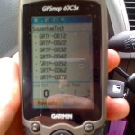
- List of waypoints
-
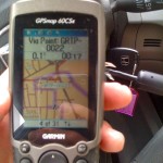
- Example direction
The problem, as you can see, is that the .gpx file imports many waypoints with non-useful names. The directions then lead you to these waypoints. At one point I was to turn right, as indicated by the map, yet I was being directed to waypoint GRTP-0032 on the LEFT. I found this to be not very helpful, quite the opposite.
While it did work, after this test I fully intend to purchase a full map from GPScity that will allow me to use BaseCamp software to plan my routes, but am awaiting more information on which map to purchase.
Thanks for reading and ride happy.

Great blog!